Canada Topo Maps 7.2.3
Free Version
Publisher Description
Canada Topo Maps - Offroad & Outdoor Navigation. Multiple Maps: Topo, Aerials, Nautical Charts, etc
Easy to use outdoor navigation app with free access to the best available maps and aerial imagery for Canada.
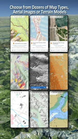
Choose between 30+ map layers (topos, aerials, sea charts, ...) to plan the perfect trip and
turn your Andoid Phone/Tablet into an outdoor GPS for offline trips into the backcountry.
*** Note: Please use Canada Base Map, Toporama or OpenStreetMap layer if you need most recent topo maps ! ***
Add easily maps from other sources (GeoPDF, GeoTiff, Online Map Services like WMS, ...)
Available base map layers for Canada:
• Canada Basemap CBMT (CanVec, NTDB, Atlas of Canada)
• Toporama Maps Canada in EN&FR (CanVec, NTDB, Atlas of Canada)
• CanTopo (new Canada Topos at 1:50.000, partial coverage of Canada, mainly in the North)
• Ontario LIO Topo Maps
• Québec Topo Maps 1:20.000
• Saskatchewan Orthophotos
• Nova Scotia Othophotos
• British Columbia Topo Maps
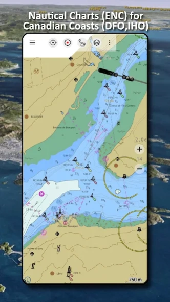
• Nautical Charts ENC
• Digital Elevation Model
• HRDEM (HiRes Elevation Model, parts of Canada)
Worldwide basemap layers:
• OpenStreetMaps (5 different map layouts), also downloadable in space saving vectorformat
• Google Maps (Satellite images, Road- and Terrain-Map)
• Bing Maps (Satellite images, Road-Map)
• ESRI Maps (Satellite images, Road- and Terrain-Map)
• Waze Roads
• Earth At Night
Configure a basemap layer as an overlay and utilize a transparency fader to seamlessly compare maps with each other.
Add maps from other sources:
• Import raster maps in GeoPDF, GeoTiff, MBTiles or Ozi (Oziexplorer OZF2 & OZF3)
• Add web mapping services as WMS or WMTS/Tileserver
• Import OpenStreetMaps in Vectorformat, eg complete USA for just some GBs
Available Canada map Overlays - add additional information to any other base map:
• CanVec features such as Transportation, Contourlines, Hydronetwork, Toponymic Features, etc.
• Nova Scotia Roads
• Yukon Transportation
Available worldwide overlays:
• Hillshading overlay
• 20m Contourlines
• OpenSeaMap
There is no perfect map. Toggle between the different map layers or use the compare maps feature to find the most interesting route. Especially the old CanMatrix Topos contain many small pathes or other features that are missing on modern maps.
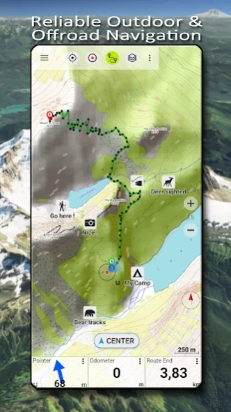
Main features for outdoor-navigation:
• Download map data for OFFLINE USAGE
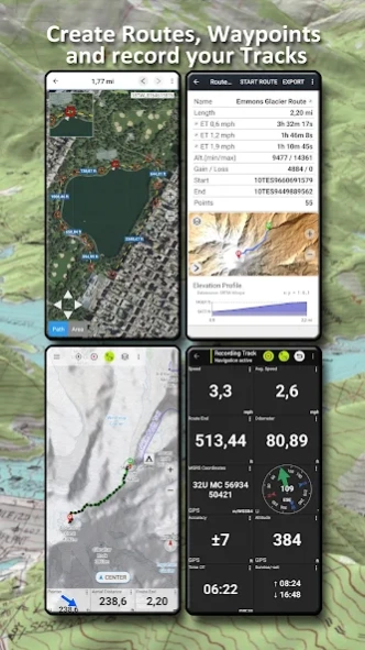
• Measure pathes and aereas
• Create and edit Waypoints
• GoTo-Waypoint-Navigation
• Create and edit Routes
• Route-Navigation (Point-to-Point Navigation)
• Track Recording (with speed, elevation and accuracy profile)
• Tripmaster with fields for odometer, average speed, bearing, elevation, etc.
• GPX/KML/KMZ Import/Export
• Search (placenames, POIs, streets)
• Get elevation and distance
• Customizable datafields in Map View and Tripmaster (e.g. Speed, Distance, Compass, ...)
• Share Waypoints, Tracks or Routes (via eMail, Dropbox, WhatsApp, ..)
• Use coordinates in WGS84, UTM or MGRS/USNG (Military Grid/ US National Grid), What3Words• Track Replay
• and many more ...
Use this navigation app for outdoor activities like hiking, biking, camping, climbing, riding, skiing, canoeing, hunting, snowmobile tours, offroad 4WD tours or search&rescue (SAR).
Add custom waypoints in longitude/latitude, UTM or MGRS/USNG format with WGS84 datum.
Import/Export/Share GPS-Waypoints/Tracks/Routes in GPX or Google Earth KML/KMZ format.
Canadian topographic maps are enhanced with Atlogis® hillshading and placenames.
Credits for topographic map data: "© Department of Natural Resources Canada. All rights reserved."
Please send questions, comments and feature requests to support@atlogis.com
About Canada Topo Maps
Canada Topo Maps is a free app for Android published in the Geography list of apps, part of Education.
The company that develops Canada Topo Maps is ATLOGIS Geoinformatics GmbH & Co. KG. The latest version released by its developer is 7.2.3. This app was rated by 1 users of our site and has an average rating of 3.0.
To install Canada Topo Maps on your Android device, just click the green Continue To App button above to start the installation process. The app is listed on our website since 2024-04-10 and was downloaded 6 times. We have already checked if the download link is safe, however for your own protection we recommend that you scan the downloaded app with your antivirus. Your antivirus may detect the Canada Topo Maps as malware as malware if the download link to com.atlogis.camaps.free is broken.
How to install Canada Topo Maps on your Android device:
- Click on the Continue To App button on our website. This will redirect you to Google Play.
- Once the Canada Topo Maps is shown in the Google Play listing of your Android device, you can start its download and installation. Tap on the Install button located below the search bar and to the right of the app icon.
- A pop-up window with the permissions required by Canada Topo Maps will be shown. Click on Accept to continue the process.
- Canada Topo Maps will be downloaded onto your device, displaying a progress. Once the download completes, the installation will start and you'll get a notification after the installation is finished.
